Kel Suu Lake
Kel Suu Lake
At 3,514 m elevation in the Kok-Kiya valley, Kel Suu Lake stretches over 10 km in a border zone. Regulated access, mineral landscapes and bivouacking.
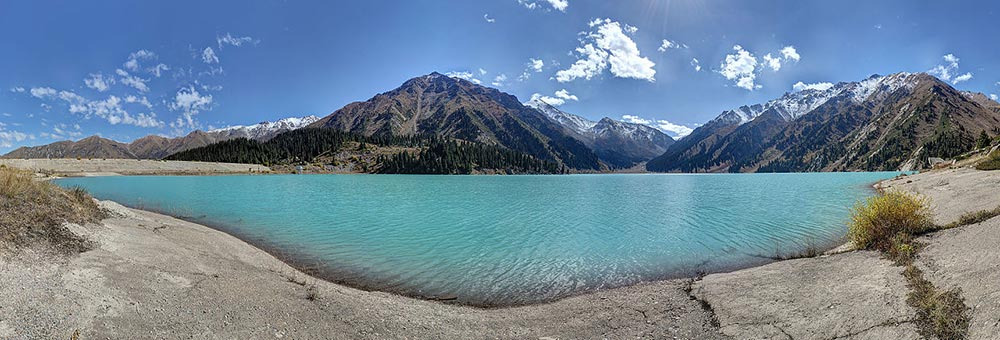
Kel Suu Lake sits at 3,514 meters elevation in the Kok-Kiya valley, Naryn region, immediately adjacent to the Chinese border. Ringed by rocky cliffs and snow-capped peaks, its turquoise waters stretch over 10 kilometers through an isolated canyon, accessible only with a special permit and roughly one hour's walk from the last road access point.
Why visit Kel Suu Lake
Kel Suu ranks among the most remote high-altitude lakes in Kyrgyzstan. Its recent formation, mineral setting, and near-total absence of infrastructure create an end-of-the-world atmosphere that is rare even by Kyrgyz mountain standards.
The site's appeal lies as much in the journey as the destination: high-altitude steppes, herds of yaks, semi-wild horses, seasonal yurt camps, and with luck, sightings of Marco Polo sheep. Marmots, far more common, announce their presence as you approach the scree slopes.
History and formation of the lake
Kel Suu is a seismic lake. It formed following an earthquake that caused a section of the surrounding massif to collapse, damming the valley and trapping meltwater and rainfall. This origin explains its elongated, narrowed form: over 10 km long with widths ranging from 0.5 to 2 km, framed by tall, jagged cliffs sometimes punctured by caves.
To the east, Sary Beles Peak dominates the landscape at 4,726 meters. The region remains sparsely inhabited, visited mainly by semi-nomadic herders during the warm season.
What to see and do
Once you've passed the final checkpoint and completed the approach hike, several activities await:
- Boat trips on the lake, organized by residents of nearby camps when conditions permit.
- Exploring the caves that punctuate the rocky walls bordering the lake.
- Bivouacking on the shores to enjoy the starlit sky and morning light on the cliffs.
- Brief swimming: water temperature hovers around 5 °C depending on season.
- Wildlife watching: yaks, horses, marmots, and occasionally Marco Polo sheep.
The lake's colors shift throughout the day, from deep green to bright turquoise as the sun moves and clouds pass.
Practical information
Permit required. Kel Suu lies in a border zone near three passes opening onto China. Visitors must pass through military checkpoints where passports and permits are systematically checked. Obtaining a permit can take more than a day and requires a passport photocopy, payment receipts, and visits to several government offices. It's wise to arrange this from Bishkek or Naryn, ideally through a local agency that handles the process.
Mobile coverage. No cellular network exists in the region. Inform loved ones before departure and consider a satellite device if you plan multiple-day bivouacs.
Food and supplies. Fresh food is scarce on-site. Stock up in Naryn before heading up; yurt camps may provide tea and occasional meals, but don't count on it.
Accommodation. No hotels: bring your own tent or arrange overnight stays in yurts with local herders present in season.
When to go
Lake access depends on elevation and trail conditions. The practical window runs roughly late June through early September. Outside this period, snow and frost make the road impassable and yurt camps are struck.
July and August bring the mildest temperatures, though nights remain cool above 3,500 meters. Always check pass conditions and weather before departing: the zone can close without notice.
How to get there
Two main departure points:
- From Naryn, plan a full day of rough 4x4 driving.
- From the Tach Rabat caravanserai, the approach is shorter but still demanding.
A 4x4 with experienced driver is strongly recommended: the track includes river crossings, wooden bridges, and several difficult sections. Standard rental vehicles won't suffice.
An alternative is to reach the lake via a multi-day horse trek, supported by a local guide and yurt relay stations. This offers the most immersive experience but requires good fitness and advance logistics planning.
The final approach, from the last parking point, is on foot: expect roughly one hour, longer depending on pace and drop-off location.
Nearby attractions
The Naryn region offers several complementary sites to pair with a Kel Suu visit:
- Naryn, the provincial capital and logistics hub for permit processing.
- The Tach Rabat caravanserai, a historic Silk Road waystation, often combined with Kel Suu.
- The Jety-Oguz valley, further north, renowned for its red rock formations.
Frequently asked questions
Frequently asked questions
Yes. The lake lies in a border zone with China and a residence permit is mandatory, verified at military checkpoints. Obtaining it can take more than a day and requires a passport photocopy and payment receipts. Working through a local agency is recommended.
Late June through early September. Outside this window, snow renders the track impassable and yurt camps aren't set up.
The final walk lasts roughly one hour from the last road access point with no major technical difficulty, but altitude above 3,500 m demands a slow pace. Prior acclimatization is recommended.
Yes, either bivouacking in your own tent or staying in yurts with local herders present in summer. No hotel infrastructure exists in the zone, and there's no mobile network.
Highly inadvisable. The track includes demanding sections. The most viable alternative is a multi-day horse trek with a local guide.
Plan your journey
Kel Suu Lake naturally fits into an itinerary combining Naryn, Tach Rabat, and the southern regions. To craft a trip suited to your dates and pace, explore our Kyrgyzstan journeys.
Interested in this visit?
We can include it in your personalised itinerary.